Valletta
25 places
Valletta’s story is written in stone and silence, in the hollows of caves and the heights of towers, in the sweep of aqueducts and the stillness of chapels. The city’s name became a fortress of faith and power, but the places that gather under this theme lie beyond its walls, each holding a fragment of Malta’s layered past. From the bone-dry mouth of Għar Dalam to the soaring dome of the Rotunda in Mosta, the route follows a thread of defence, devotion and discovery. It begins where the island’s earliest footsteps were preserved, climbs to the watchful eyes of de Redin’s towers, pauses in the gardens of presidents and the trenches of the Victoria Lines, and ends where the sea still answers to the old alarms.
Bones of the past in Birżebbuġa
Għar Dalam opens like a dark yawn above the limestone cliffs of south-east Malta. The cave’s mouth, eleven metres wide and standing only fifteen and a half metres above the tide, frames a passage that plunges 145 metres into the rock. A paved walkway, lit and level, carries visitors eighty metres into the belly of the hill, past walls polished by Pleistocene rivers that once carved this hollow from the living stone. Above the entrance, a small museum keeps the bones that Arturo Issel and John Henry Cooke pulled from the clay in the 1800s—hippopotamus femurs and dwarf-elephant molars that speak of a wetter world when Wied Dalam ran full and wild. During the Second World War, the same galleries that once held Ice Age beasts sheltered fuel drums and families from the sky.
A dome that defied a bomb in Mosta
The Rotunda of Mosta rises above the flatlands of central Malta, its vast circle of masonry visible for miles. Giorgio Grognet de Vassé shaped the church on the model of Rome’s Pantheon, giving it an outer diameter of nearly fifty-five metres and an internal dome that climbs more than fifty-six metres above the floor. Inside, gold leaf and blue paint glow across marble floors and altarpieces by Stefano Erardi, while a copy of the unexploded Luftwaffe bomb of 1942 rests in the sacristy as silent witness. The congregation that afternoon counted three hundred souls; none were harmed when the shell pierced the shell of the dome and fell unlit to the flagstones.
A president’s baroque retreat in Attard
San Anton Palace sits behind high walls and clipped hedges in the village of Attard, its baroque façade softened by gardens that have been open to the public since 1882. Antoine de Paule, Grand Master of the Knights of St John, commissioned the summer residence between 1623 and 1636, and later British governors turned its halls into the seat of colonial rule. A private chapel wears the heraldic shields of later Grand Masters, while a belvedere tower looks out over the Maltese uplands. The orange groves and gravel paths laid out for the knights still invite slow strolls among the stone benches and fountains.
A scar across the island’s spine
The Victoria Lines stretch for just over ten kilometres along the natural fault that splits Malta from west to east, a scar of masonry that begins at Fomm-ir-Riħ on the west coast and ends at Fort Madliena in the east. The Knights of Malta began the work in the 18th century, but it was the British who, in 1890, crowned the ridge with forts, batteries and barracks and named the line in honour of Queen Victoria’s diamond jubilee. Though never bloodied in battle, the wall and its outworks tell of imperial engineering and the island’s strategic obsession. Today the best-preserved stretches lie between Nadur and Falka Gap, where walkers can follow the crest and peer down into valleys that once funnelled armies.
Bronze Age walls by the bay
Borġ in-Nadur crouches in the open fields above St George’s Bay, its megalithic temple and later Bronze Age village sharing the same windswept plateau. The temple, dating from the Tarxien phase, shows the classic four-apse plan but stands low and unadorned. Overlying it, the villagers built a semicircular curtain wall nearly five metres high—the oldest surviving fortification on the island—designed to fend off raids from the landward side. Bronze Age ruts in the limestone and storage silos hint at trade links that reached across the Aegean. A single cross now marks the hill where later generations claimed visions of the Virgin, though the Church has never confirmed them.
Water on stone from Mdina to Valletta
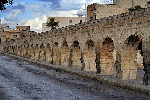
The Wignacourt Aqueduct carries the memory of water across sixteen kilometres of Maltese countryside, rising from the clay beds beneath Mdina and ending in the cisterns of Valletta. Built between 1610 and 1614 under Alof de Wignacourt, the stone arches snake eastward, their heights varying with the lie of the land—low over the gentle slopes near Balzan, tall and proud above Birkirkara and Santa Venera. In Santa Venera the conduit disappears underground, monitored by inspection towers that still stand in Ħamrun and Floriana. The work was born of thirst: after the Great Siege of 1565, the new city needed a steady flow, and the aqueduct answered for centuries before a second conduit from Fawwara took up the task.
Watchers on the northern cliffs
The Qalet Marku Tower, built in 1658–59 under Grand Master Martin de Redin, stands square and solid on the headland of Qrejten Point near Naxxar. With sides of eight metres and a height of twelve, it could lodge stores and mount a small cannon on its roof, while its sightlines reached west to the Għallis Tower and east to Madliena. A nearby redoubt, a five-sided earthwork, later added to the defences. When British officers in the 19th century talked of demolition, the tower survived and now stands under state protection, a quiet sentinel over the north coast.
A football stage in Ħamrun
The Victor Tedesco Stadium is a compact temple to the round ball, seating 1,962 spectators in a single tier of seats in the southern town of Ħamrun. Named after a former president of Ħamrun Spartans, the ground has been home to the club since its opening, its modest scale creating an intimacy that larger arenas cannot match. Match days bring a local pulse to the neighbourhood, where the colours of the Spartans flutter above the turnstiles and the floodlights cut through the Mediterranean dusk.
A medieval jewel near Gudja
Santa Marija ta’ Bir Miftuħ began as a chapel around 1430 and grew into a parish church by the 16th century, its long rectangle topped by a gently sloping roof. Gothic pointed arches still frame the west door, while a later baroque belfry rises above the gable, its bells ringing out over the fields that once fed the villages of the south. Inside, a recently uncovered fresco of the Last Judgement watches over the single oval window that lets in shafts of light. Since 1970 the chapel has been cared for by Din l-Art Ħelwa, and each summer the Bir Miftuħ International Music Festival draws visitors to its stone benches and ancient walls.
See all places on the map